Historic St.Stephen's : Various articles
An occasional series of articles on Historic St.Stephen's with help from our residents.
Historic St.Stephen's Film Clip
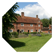
 Follow the link below to see a clip of film shot in approximately 1927 showing the entrance to Hale’s Place in Canterbury and a tantalising glimpse of the mansion in the distance through the trees : Canterbury Amateur Film Archive.
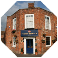
Sydney Bligh owned S.W. Bligh, a radio shop on North Lane. He was a keen amateur filmmaker who went onto produce an annual Canterbury newsreel between 1934 to 1939.
Follow the link below to see a clip of film shot in approximately 1927 showing the entrance to Hale’s Place in Canterbury and a tantalising glimpse of the mansion in the distance through the trees : Canterbury Amateur Film Archive.Sydney Bligh owned S.W. Bligh, a radio shop on North Lane. He was a keen amateur filmmaker who went onto produce an annual Canterbury newsreel between 1934 to 1939.
Compare historic maps of Canterbury to modern map or satellite
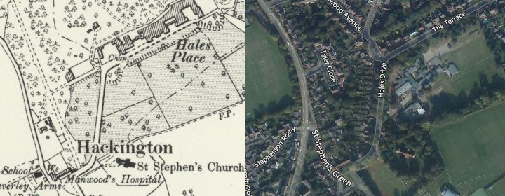
Thanks to the National Library of Scotland you can see St Stephen's, or wherever you wish in Canterbury, as it is now and how it was according to old maps, as with this slice of St.Stephen's below. Follow this link to their website for the full functionality.
Canterbury Map Stitch
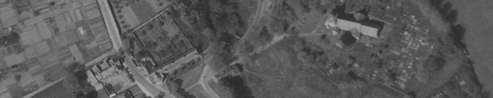
Mapping Kent currently have a number of works in progress, focusing on the 1946 aerial photography collection held by KCC. The team has been commissioned to create 'stitches' for a number of areas, including Canterbury, Faversham and Margate. The small slice below covers The Beverlie and the Church. Follow this link to their website for the full pictures.
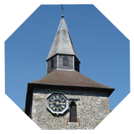
a mystery solved ?
we asked what you knew about the 'monument or plinth' on the corner of Manwood Ave & Hales Drive
For our 'Christmas Mystery 2014', after we were contacted by the Historic Environment Records Manager at Kent County Council concerning the 'monument or plinth', which stands on the corner of Manwood Avenue and Hales Drive, who believed that the KCC Highways were responsible for maintaining it, we asked you what you knew about it. Suggestions ranged from the base for a statue, a monument or perhaps the pillar of one side of a gateway.
Amongst the recollections and stories submitted were;
So what is the verdict, well we have three votes for 'gatepost' but the evidence points strongly against this;
we asked what you knew about the 'monument or plinth' on the corner of Manwood Ave & Hales Drive
For our 'Christmas Mystery 2014', after we were contacted by the Historic Environment Records Manager at Kent County Council concerning the 'monument or plinth', which stands on the corner of Manwood Avenue and Hales Drive, who believed that the KCC Highways were responsible for maintaining it, we asked you what you knew about it. Suggestions ranged from the base for a statue, a monument or perhaps the pillar of one side of a gateway.
Amongst the recollections and stories submitted were;
"The Jesuits had a number of statues dotted around the site. There was a large statue in the garden of no. 7, Manwood Avenue, long since demolished".
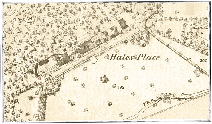
"I noted your comment about the "ruined gatepost" at the corner of Hales Drive and Manwood Avenue. If you look at it carefully you'll see it would be impossible to hang a gate on it because of its shape and there is no evidence of any hinge attachment points. It is in fact a plinth for a statue or urn or some other decorative feature, one of the few remaining reminders of the house and seminary at Hales Place. On the 1870s OS plan there is a circle at that location which may well represent it".
"With regard to the stone artefact, I always thought that it was the remains of a gatepost although I do not remember whether I read or was told this. The Ordnance Survey map published in 1880 shows the village of Hackington including Hales Place House and park land in detail. Two circles are shown on the map at the junction of what is now Hales Drive and the Terrace. The second one is located at a point that would have been approximately in the middle of the grassy island at the beginning of Manwood Avenue where we recently planted bulbs. They appear to mark the entrance to the extensive formal gardens and parkland where a number of pathways used to converge to the left of Hales Place house. This included a continuation of the Terrace that led towards what is now St Stephens Hill, but did not appear to open on to it".
"I've always understood it to have been the left hand one of two hefty gateposts at the top of the tree-lined drive up to Hales Place, the big house that stood where the houses of The Terrace now are".
"My uncle who was working nearby in the early 50s tells me part of the gate was then still in situ".
Here is the section reproduced from the 1880 Ordnance Survey map mentioned :"I noted your comment about the "ruined gatepost" at the corner of Hales Drive and Manwood Avenue. If you look at it carefully you'll see it would be impossible to hang a gate on it because of its shape and there is no evidence of any hinge attachment points. It is in fact a plinth for a statue or urn or some other decorative feature, one of the few remaining reminders of the house and seminary at Hales Place. On the 1870s OS plan there is a circle at that location which may well represent it".
"With regard to the stone artefact, I always thought that it was the remains of a gatepost although I do not remember whether I read or was told this. The Ordnance Survey map published in 1880 shows the village of Hackington including Hales Place House and park land in detail. Two circles are shown on the map at the junction of what is now Hales Drive and the Terrace. The second one is located at a point that would have been approximately in the middle of the grassy island at the beginning of Manwood Avenue where we recently planted bulbs. They appear to mark the entrance to the extensive formal gardens and parkland where a number of pathways used to converge to the left of Hales Place house. This included a continuation of the Terrace that led towards what is now St Stephens Hill, but did not appear to open on to it".
"I've always understood it to have been the left hand one of two hefty gateposts at the top of the tree-lined drive up to Hales Place, the big house that stood where the houses of The Terrace now are".
"My uncle who was working nearby in the early 50s tells me part of the gate was then still in situ".
The two monuments/plinths/gateposts are the two circles highlighted in pink at the western end of the terrace, running across the front of the Hales Place buildings, of which the southerly one is the survivor, the other would presumably have stood where the grassy island at the beginning of Manwood Avenue is now situated.
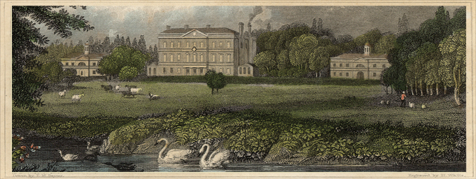
The area where the 'two pink circles' at the western end of The Terrace would have stood is hidden by the trees on the left of this original coloured engraving taken from the area marked as 'The Canal' on the 1880 OS map.
Conclusions :So what is the verdict, well we have three votes for 'gatepost' but the evidence points strongly against this;
(i) the inner face of the gatepost is not one continuous vertical face, but a wide base which steps twice below the main part of the plinth, which is the capped with a wider top, before sloping inwards again,
(ii) there are no signs of fixtures or fittings on the inner face on which a gate might have hung,
(iii) the ground where the second pillar stood is appreciably higher than the first, meaning any gate would not have stood on level ground, although the construction of Manwood Avenue may have altered the lie of the land.
So who is right ? Perhaps everyone is! Maybe the ornamental stone faced pillars once held statues or urns and a narrower pair of wooden gates stood within these on timber posts which no longer survive ? The jury is still out! Do you know more ?
(ii) there are no signs of fixtures or fittings on the inner face on which a gate might have hung,
(iii) the ground where the second pillar stood is appreciably higher than the first, meaning any gate would not have stood on level ground, although the construction of Manwood Avenue may have altered the lie of the land.